Newly circulated Israeli maps outlining an expanded zone of military control in Gaza have raised alarm among humanitarian agencies and analysts, as the conflict enters a more entrenched and uncertain phase.
The maps, shared with aid organizations but not officially published, indicate a significant enlargement of restricted military areas across the enclave, intensifying concerns about displacement, humanitarian access and the long-term future of Gaza.
Expanded control zones revealed
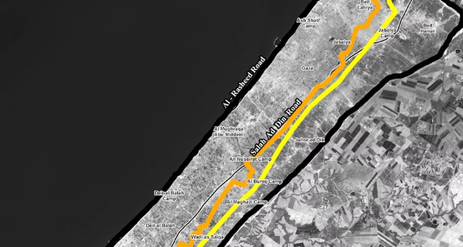
According to recent reports, the maps introduce a newly defined “orange line” marking restricted areas that extend Israel’s control deeper into Gaza. The updated demarcations suggest that nearly two-thirds of the territory is now either under Israeli control or subject to military restrictions.
This represents a notable expansion from earlier ceasefire arrangements in late 2025, when Israeli forces controlled just over half of the enclave under the so-called “yellow line” boundary.
The lack of formal public clarification from Israeli authorities has contributed to confusion among both civilians and aid groups attempting to navigate the shifting landscape.
Humanitarian concerns intensify
Aid organizations operating in Gaza say the evolving map of control zones is complicating relief efforts. Workers report difficulties coordinating safe access routes, with some areas becoming restricted without clear warning.
Recent incidents have heightened fears, including the deaths of aid workers within newly designated zones.
Humanitarian groups warn that the expansion effectively confines large numbers of Palestinians to increasingly smaller areas, placing severe strain on already limited resources such as food, water and medical care.
The United Nations and other agencies have previously cautioned that such restrictions risk making significant portions of Gaza uninhabitable.
Displacement and territorial shifts
The expansion of military zones is part of a broader pattern seen since the start of the war in October 2023, when Israel began carving out buffer zones and restricting civilian movement.
Analysts say the newly revealed maps suggest a continuation and possible acceleration of that strategy.
Reports indicate that shifting boundaries have led to repeated displacement, with families forced to relocate multiple times as front lines and restricted zones move.
Critics argue that these changes may amount to a de facto redrawing of Gaza’s geography, with long-term implications for any future political settlement.
Security rationale vs. international criticism
Israel maintains that the expansion of controlled areas is necessary for security purposes, including preventing militant activity and facilitating safer delivery of humanitarian aid.
However, human rights organizations and legal experts have raised concerns about the legality of expanding military zones in densely populated civilian areas.
Some analysts warn that the steady movement of boundaries such as the previously established “yellow line” could signal an effort to establish more permanent control over parts of Gaza.
Wider conflict context
The developments come amid ongoing violence despite a formal ceasefire declared in October 2025. Israeli strikes and military operations have continued intermittently, contributing to a mounting death toll and widespread destruction.
The war, triggered by the October 7, 2023 Hamas-led attack on Israel, has devastated Gaza’s infrastructure and displaced much of its population, with reconstruction expected to take years.
Outlook
With the situation on the ground continuing to evolve, the newly revealed maps underscore the fragility of the current ceasefire and the challenges facing diplomatic efforts.
As military control zones expand and humanitarian conditions worsen, the risk of prolonged instability and the potential reshaping of Gaza’s territorial reality remains a central concern for the international community.
________________________________________________________________________________________________________________